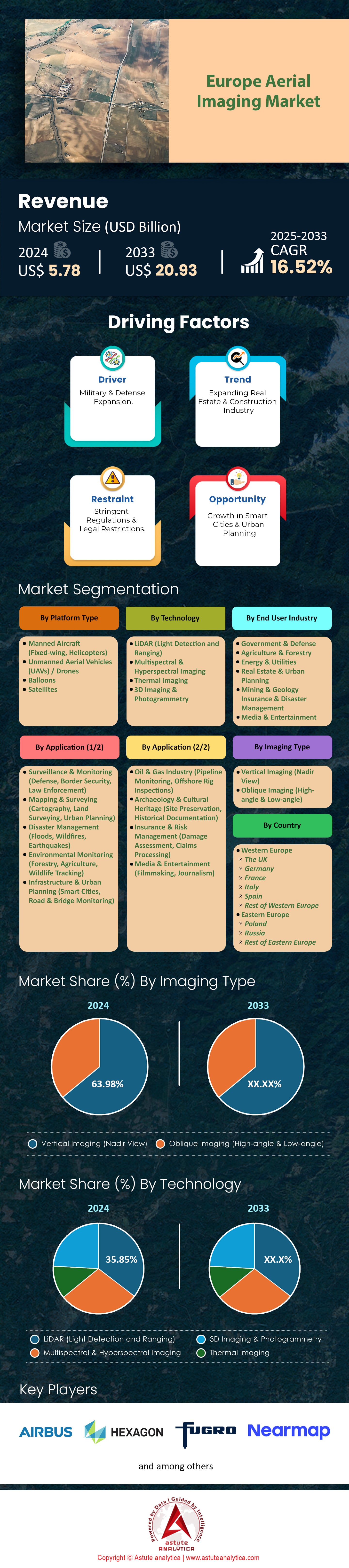
-->
24/7 Customer Support
1.1. Research Objective
1.2. Product Overview
1.3. Market Segmentation
2.1. Qualitative Research2.1.1. Primary & Secondary Sources
2.2. Quantitative Research2.2.1. Primary & Secondary Sources
2.3. Breakdown of Primary Research Respondents, By Region
2.4. Assumption for the Study
2.5. Market Size Estimation
2.6. Data Triangulation
Executive Summary: Europe Aerial Imaging Market
4.1. Industry Value Chain Analysis4.1.1. Service Provider4.1.2. End User
4.2. Industry Outlook4.2.1. Aerospace and Defense Spending - Europe 4.2.2. Agriculture Industry - Europe
4.3. PESTLE Analysis
4.4. Porter's Five Forces Analysis4.4.1. Bargaining Power of Suppliers4.4.2. Bargaining Power of Buyers4.4.3. Threat of Substitutes4.4.4. Threat of New Entrants4.4.5. Degree of Competition
4.5. Market Dynamics and Trends4.5.1. Growth Drivers4.5.2. Challenges4.5.3. Key Trends
4.6. Market Growth and Outlook4.6.1. Market Revenue Estimates and Forecast (US$ Bn), 2020-20334.6.2. Price Trend Analysis
4.7. Competition Dashboard4.7.1. Market Concentration Rate4.7.2. Company Market Share Analysis (Value %), 20244.7.3. Competitor Mapping
4.8. Actionable Insights (Analyst's Recommendations)
5.1. Key Insights
5.2. Market Size and Forecast, 2020-2033 (US$ Bn)5.2.1. Manned Aircraft (Fixed-wing, Helicopters)5.2.2. Unmanned Aerial Vehicles (UAVs) / Drones5.2.3. Balloons 5.2.4. Satellites
6.1. Key Insights
6.2. Market Size and Forecast, 2020-2033 (US$ Bn)6.2.1. LiDAR (Light Detection and Ranging)6.2.2. Multispectral & Hyperspectral Imaging6.2.3. Thermal Imaging6.2.4. 3D Imaging & Photogrammetry
7.1. Key Insights
7.2. Market Size and Forecast, 2020-2033 (US$ Bn)7.2.1. Vertical Imaging (Nadir View)7.2.2. Oblique Imaging (High-angle & Low-angle)
8.1. Key Insights
8.2. Market Size and Forecast, 2020-2033 (US$ Bn)8.2.1. Surveillance & Monitoring (Defense, Border Security, Law Enforcement)8.2.2. Mapping & Surveying (Cartography, Land Surveying, Urban Planning)8.2.3. Disaster Management (Floods, Wildfires, Earthquakes)8.2.4. Environmental Monitoring (Forestry, Agriculture, Wildlife Tracking)8.2.5. Infrastructure & Urban Planning (Smart Cities, Road & Bridge Monitoring)8.2.6. Oil & Gas Industry (Pipeline Monitoring, Offshore Rig Inspections)8.2.7. Archaeology & Cultural Heritage (Site Preservation, Historical Documentation)8.2.8. Insurance & Risk Management (Damage Assessment, Claims Processing)8.2.9. Media & Entertainment (Filmmaking, Journalism)
9.1. Key Insights
9.2. Market Size and Forecast, 2020-2033 (US$ Bn)9.2.1. Government & Defense9.2.2. Agriculture & Forestry9.2.3. Energy & Utilities9.2.4. Real Estate & Urban Planning9.2.5. Mining & Geology9.2.6. Insurance & Disaster Management9.2.7. Media & Entertainment
10.1. Key Insights
10.2. Market Size and Forecast, 2020-2033 (US$ Bn)10.2.1. Western Europe10.2.1.1. The UK10.2.1.2. Germany10.2.1.3. France10.2.1.4. Italy10.2.1.5. Spain10.2.1.6. Rest of Western Europe10.2.2. Eastern Europe10.2.2.1. Poland 10.2.2.2. Russia10.2.2.3. Rest of Eastern Europe
11.1. Key Insights
11.2. Market Size and Forecast, 2020-2033 (US$ Bn)11.2.1. By Platform Type11.2.2. By Technology11.2.3. By Imaging Type11.2.4. By Application 11.2.5. By End User Industry
12.1. Key Insights
12.2. Market Size and Forecast, 2020-2033 (US$ Bn)12.2.1. By Platform Type12.2.2. By Technology12.2.3. By Imaging Type12.2.4. By Application 12.2.5. By End User Industry
13.1. Key Insights
13.2. Market Size and Forecast, 2020-2033 (US$ Bn)13.2.1. By Platform Type13.2.2. By Technology13.2.3. By Imaging Type13.2.4. By Application 13.2.5. By End User Industry
14.1. Key Insights
14.2. Market Size and Forecast, 2020-2033 (US$ Bn)14.2.1. By Platform Type14.2.2. By Technology14.2.3. By Imaging Type14.2.4. By Application 14.2.5. By End User Industry
15.1. Key Insights
15.2. Market Size and Forecast, 2020-2033 (US$ Bn)15.2.1. By Platform Type15.2.2. By Technology15.2.3. By Imaging Type15.2.4. By Application 15.2.5. By End User Industry
16.1. Key Insights
16.2. Market Size and Forecast, 2020-2033 (US$ Bn)16.2.1. By Platform Type16.2.2. By Technology16.2.3. By Imaging Type16.2.4. By Application 16.2.5. By End User Industry
17.1. Key Insights
17.2. Market Size and Forecast, 2020-2033 (US$ Bn)17.2.1. By Platform Type17.2.2. By Technology17.2.3. By Imaging Type17.2.4. By Application 17.2.5. By End User Industry
18.1. Key Insights
18.2. Market Size and Forecast, 2020-2033 (US$ Bn)18.2.1. By Platform Type18.2.2. By Technology18.2.3. By Imaging Type18.2.4. By Application 18.2.5. By End User Industry
19.1. AHM (Airborne Hydromapping)19.2. Air Columbus19.3. CGR Spa Compagnia19.4. Flycom Technologies19.1. Mapsoft19.5. Photomap19.6. Primis19.7. Sintégra19.8. Vansteelandt19.9. Aerodata Inc.19.10. Aeronike19.11. AVT Airborne Sensing19.12. Bluesky19.13. GISPRO19.14. Milan Geoservice19.15. Miramap Aerial Surveys19.16. BSF Swissphoto19.17. GeoFLy19.18. Hexagon19.19. Kavel 1019.20. TopGis19.21. Vermessung Meixner19.22. Eurosense19.23. Hansa Luftbild19.24. Opegieka19.25. Pixair19.26. SPASA19.27. Aero Photo Europe Investigation (APEI)19.28. MGGP Aero19.28. Slagboom & Peeters19.20. Swiss Flight Services19.31. Other Prominent Players
20.1. List of Secondary Sources20.2. Key Country Markets - Macro Economic Outlook/ Indicators
✓
User Sharing
1 User Only
Up to 7 Users
Unlimited User Access
Print
⨉
Free Customization
No Free Customization
Up To 30 hrs work
Up To 60 hrs work
Up To 80 hrs work
Deliverable Format
PDF
Excel
Power Point (PPT)
Analyst Support
2-Months Analyst Support
4-Months Analyst Support
7-Months Analyst Support
One Year Analyst Support
Free Report update in next
update cycle
Free Industry Update
(Within 180 days)
Benefit
Up to 10% off on Post Purchase
Up to 20% off on Post Purchase
Up to 30% off on Post Purchase
Up to 40% off on Post Purchase
We use Cookies×
to improve your experience.